Earth 3D Map-StreetView: 6 distance-measuring tips
I’ll help you measure routes, sites and boundaries with less guesswork before you commit to a stop or detour.
Mateo IrvingReviewer · published Oct 26, 2026 · 6 min read
01Start in Satellite Map before dropping a measurement point
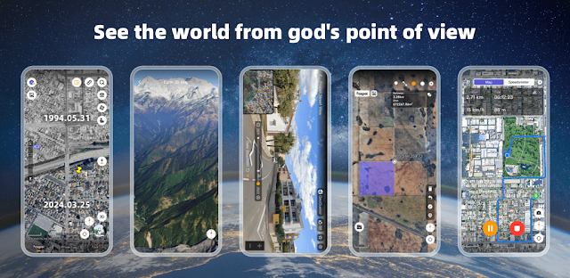
I start with Satellite Map when I need to judge a practice field, trailhead or building entrance, because the plain world map can hide the detail that makes a measurement useful. Search for the place first, then zoom until you can separate paths, parking areas, fences and the edge of the usable ground. A line drawn between vague points is only a neat-looking guess.
Use the globe view for the broad approach, then move to the flatter satellite view as you get close. Pinch with two fingers to zoom, drag with one finger to reposition, and use a two-finger rotation only when it helps you follow an angled road or shoreline. This pays off when a route bends around terrain rather than crossing it.
Before measuring, pause on the exact start and finish locations. A gate, curb cut, footbridge or trail marker is usually a better endpoint than the middle of a large place. That small bit of setup makes every later tap more dependable.
02Use the compass to stop measuring in the wrong direction
A map that has quietly rotated can make a simple north-to-south walk feel hard to read. I check the compass before planning access from a car park to an entrance, especially after twisting the globe with two fingers. Tap the compass control to return the map to north-up, then trace the route with the screen steady.
North-up is best for sharing directions and comparing the route with another map later. Keep the rotated view only when it gives you a clearer look at a hillside, waterfront or a block of buildings. The compass is not decoration here; it is the quick reset that keeps left, right and straight ahead meaningful.
This matters when arranging car rental pickup or checking a venue reached from an unfamiliar junction. A short walking distance can still be awkward if the usable entrance sits on the opposite side of a divided road. Next, choose the right measuring tool for that detail.
03Measure a walking line, then measure the whole usable area
Use the distance measurement control for a route: gate to entrance, parking row to trailhead, or one corner of a park to another. Place the first point carefully, add points at each meaningful turn, and finish at the real destination. Extra points on curves and switchbacks make the line follow the ground route instead of cutting across grass, water or buildings.
Switch to area measurement when the question is about space rather than travel. Outline the edge of a field, a picnic lawn, a parking section or an open viewing area by placing points around its boundary, then close the shape. Keep your points on visible edges such as fencing, pavement or tree lines rather than estimating an invisible border.
I use both views before putting a place into a trip planner. The route measurement answers how far people move; the area outline answers whether the place looks big enough for the plan. Those are different decisions, and the app keeps them separate if you do too.
04Check Historical Street View for entrances that satellite images blur
Satellite imagery is strong for layout, but it can leave the last few metres unclear. Open Historical Street View around the route endpoint and look at the approach: driveway signs, pedestrian gates, pavement gaps, loading entrances and the side of the building facing the road. Move along the street view path rather than relying on one viewpoint.
The historical option is useful when an entrance looks different from the surrounding map image. Compare a couple of available street-level views, then return to Satellite Map and keep your final measurement tied to a visible landmark. Treat street imagery as a planning aid, not a promise that every sign or barrier will match your arrival.
This is particularly handy when comparing hotel deals near an event location. Two places can look equally close on a search result, while one requires a longer walk around a rail line, river or fenced block. Street-level context catches that kind of inconvenience early.
05Import a GPX or KML route instead of rebuilding every turn
If someone has already shared a route or site boundary, look for the app’s file import option before placing a long chain of points yourself. Earth 3D Map-StreetView Camera supports map project formats including GPX, KML, KMZ, CSV and GeoJSON, so a route can begin as an existing line instead of a blank screen.
After selecting a file, zoom to its start, middle and endpoint. Check that the line sits on the intended road, path or boundary, then use the measurement feature only for the section you need to compare. A GPX track can be especially useful for a trail, while a KML boundary is a sensible starting point for a defined site.
Keep the imported item focused on one question. For travel booking, I would use a route file to assess the transfer from a station or airport area, not pile unrelated markers onto the same map. A clean map is easier to revisit when plans shift.
06Save the place with UTM or MGRS when an address is not enough
Addresses are poor labels for remote meeting spots, large parks and open land. When you find the exact point, use the coordinate display and note the UTM or MGRS reference alongside a plain-language label such as “east gate” or “riverside parking.” These coordinate formats help you return to the same physical point after panning away.
First place the map marker directly on the landmark, then verify the compass orientation and zoom level before copying the coordinates into your own notes. Avoid taking coordinates from the middle of a wide road or a broad building roof. A small movement on the screen can represent a very different arrival point on the ground.
This pays off when flights, vacation packages or a changed itinerary put you in an unfamiliar area. You can reopen the map, enter the saved reference and immediately see the precise point you meant, rather than searching through similarly named places.
The takeaway
First, search for the location, switch to Satellite Map, reset north with the compass and measure the real route between visible landmarks. Use area measurement only after the route is clear, then check Street View where the entrance could change the plan.
Continue to The Considered Pick’s Earth 3D Map-StreetView page just below for the app details and current Google Play information.
The Considered Pick is independent and not affiliated with Foxpoi. This guide reflects the reviewer's own setup; menus can differ by device and version.
 Best picksMy Location
 TipsCurrency converter offline
 TroubleshootingCode Studio
 CompareGps Map Navigation &
 How-toThe Official MTA App
 Tipsearnify

 How-toCelebrity Cruises
 How-toRemote Control for Rоku &

 TipsInvitation Maker

 TipsGmail
 TipsCamera Translator